Florida Keys Mile Marker Chart – List
- November 8, 2014
- iris
- Uncategorized
- No Comments
This list of MM’s are approximate.
Items listed in italics are historical locations and may not still physically exist.
127.5 = Florida City – Junction with Fla. Turnpike and U.S. 1..
126.5 = Junction U.S. 1 with CR-905 to/from Card Sound Bridge and Ocean Reef Club, Oceanside. Also an alternate route, $1.00 bridge toll, if southbound.
126.0 = End/Begin two-lane “18 Mile Stretch.” If southbound, please drive carefully.
123.5 = Florida Sand and Gravel site, Oceanside
123.0 = Dade Correctional Institution, gulfside
118.0 to 121.0 = Four-lane passing zone
119.5 = Dirt road turn-off, gulfside
116.3 = C-111 Aerojet canal bridge
114.1 = to 116.0 Four-lane passing area.
114.0 = South Dade Marina & boat storage, Oceanside
112.5 = MONROE COUNTY LINE – Leave Dade County if southbound.
110.8 = FKAA Water Pump Station, Oceanside. Little Black Water Sound Boat Ramp, gulfside
109.3 = Osprey bird nest, Oceanside
108.0 = Osprey nest, Oceanside.
107.2 = Jewfish Creek drawbridge. Exit/enter Key Largo. Begin “18-Mile Stretch.” If northbound, please drive carefully.
106.6 = Lake Surprise
106.5 = Card Sound Bridge turnoff to/from Ocean Reef via CR 905 Oceanside. Also an alternate route, $1.00 bridge toll, northbound to Homestead.
If taking CR905, the following MM’s apply and are labeled “C”. At C-5 soundside is the solid waste transfer facility. At C-7 oceanside is the former Carysfort Campground. At C-7.5 soundside was the former Nike missile launch site. At C-8.5 oceanside is the remains of the Nike missile radar site. At C-9.25 is a three way stop. Straight goes to the Anglers and Ocean Reef Clubs gated communities. Left goes across the Cardsound toll bridge to Homestead. At C-11 to the left is the Angler’s Club and straight ahead is the Ocean Reef Club. Now back to MM’s.
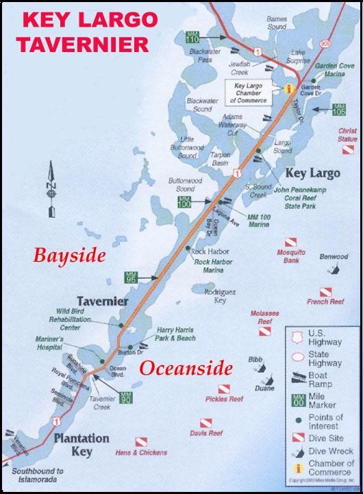
106.0 = Key Largo Chamber of Commerce, gulfside; FKEC Power sub-station oceanside
105.9 = County Animal shelter, oceanside
105.6 The location of the railroad depot and the center of the community of Key Largo from about 1910 to 1940. The depot was in the highway median. The community was gulfside.
105.5 = St. Justin Catholic Church, gulfside
105.4 = Winn-Dixie Shopping Center, gulfside
105.3 = Stillwright Point community entrance, gulfside
105.0 = Cracked Conch Restaurant, oceanside
104.8 = Key Largo Elem. School, oceanside
104.5 = Taylor Creek Village, oceanside; Tamarind Park, gulfside
104.1 = Caribbean Club, gulfside. The set for the 1948 movie Key Largo was modeled for this location.
104.0 = Big Chill Restaurant, gulfside
103.5 = The 1920s Key Largo Rock Castle, End of Oceana Drive, Oceanside.
103.4 = Marvin Adams Waterway Bridge (The Cut), a canal that connects Atlantic to Florida Bay
103.8 = Central (Pink) Plaza Shop Center, gulfside
102.8 = John Pennekamp State Park entrance, oceanside
101.5 = Tarpon Basin Road, Key Largo Library, Tradewinds Shopping center, oceanside
101.2 = Hibiscus Park, Oceanside. The was the center of the 1880s community of Newport.
101.0 = KLI Building Supply (Orange Roof), Colusa Trailer Park, gulfside
99.8 = Key Largo Post Office- ZIP 33037, gulfside
98.0 = Landings of Largo, gulfside; Moose Lodge oceanside; Everglades Park Ranger Station, gulfside.
1st Baptist Church, oceanside; Shell World (center road); Rock Harbour Club, gulfside & Mariners Club oceanside
95 to 100 = This was the early community of Rock Harbour. A small railroad depot was also here.
97.0 = Hilton Hotel, gulfside
96.0 = Silver Shores community, oceanside; Winken Blinkin and Nod Estates, oceanside. Buttonwood Bay gulfside
95.3 = Key Largo Ocean Resorts, oceanside. Key Largo Prof. Center., gulfside.
95.2 = Florida Keys National Marine Sanctuary building.
94.8 = Seaside community, oceanside. The 1900s Thompson line packing house was in this area.
94.0 = Red Cross Center, gulfside; Glander Boats oceanside, Sunset Hammock, gulfside.
93.8 = Wild Bird Center, gulfside
93.1 = Hammer Point community, WFKZ Radio tower and offices, gulfside.
92.9 = Jewish Center, oceanside
92.8 = Burton Memorial United Methodist Church, oceanside
92.6 = Burton Drive, Harry Harris Park oceanside. The early community of Planter included the park area, but the community center was about 1,000 feet south.
92.2 BPOE Lodge, Bank of America, gulfside; Driftwood Trailer Park, oceanside
91.9 Old Tavernier Post office; Old Settlers Park, oceanside Tavernier Hotel, oceanside. This was the center of the early community of Tavernier. Its depot was in the median just south of the post office.
91.8 = Reporter Newspaper; FKEC Power Station, Oceanside; FKAA, gulfside
91.3 = Tavernier Town Shopping Center, Mariners Hospital, Post Office – ZIP 33070, gulfside
91.0 = Tavernier Creek Bridge; enter Islamorada; Tavernier Creek Marina, Plantation Marina, gulfside
90.8 = Turek Building, gulfside
90.1 = Plantation Key Colony community entrance, gulfside; Immanuel Lutheran Church, oceanside. A large Indian mound existed in the center of the subdivision.
90.05 = End 4-lane highway if going south.
90.0 = Coral Isles Church; Coral Shores High School, Oceanside; Plantation Key Elementary School
89.5 = San Pedro Catholic Church, gulfside
88.5 = Plantation Key Government Center, Sheriff, Courthouse, Building/Zoning/Tax Collector/ Assessor; Convalescent and Children’s Center; Old Mariner’s Hospital, gulfside
88.0 = Futura Yacht Club, gulfside; Plaza 88; Plantation Key Professional Building, oceanside
87.5 = St. James Fisherman Episcopal Church, Executive Bay Club, Gulfside
87.0 = Founders Park (Plantation Yacht Harbor), gulfside
86.8 = Treasure Village, Oceanside; Rainbarrel, gulfside
86.0 = Weigh station for trucks, oceanside WXOS Radio station and tower, Venetian Shores subdivision
85.5 = Snake Creek Draw Bridge; Coast Guard Station, gulfside Enter Windley Key
85.3 = Windley Key State Fossil Reef Geological Site, gulfside
84.3 = This was the center of the community of Quarry that thrived during the construction of the railroad.
84.2 = Theater of the Sea; Holiday Isle Resort oceanside.
84.0 = Whale Harbor Bridge.
83.4 = Island Christian School, gulfside; Whale Harbor Inn, oceanside
82.2 = Islamorada Chamber of Commerce Red Caboose
82.6 = Islamorada Post Office- ZIP 33036, oceanside
81.5 = Islamorada Library and park, gulfside; Hurricane Memorial; Cheeca Lodge, Oceanside. The library was constructed as a Hurricane Refuge School after the 1935 Hurricane. During construction, the Florida Keys Memorial, know as the Hurricane Monument, was also constructed and dedicated.
81.2 = Worldwide Sportsman; gulfside; Moose Lodge
81.3 = Green Turtle Inn; Oceanside. Part of the structure survived the 1935 Hurricane.
80.0 = Roadside park, gulfside
79.8 = Tea Table Relief Bridge. Papa Joe’s Marina, gulfside; Bud and Mary’s, oceanside. The north
approach washed out during Hurricane Donna, 1960.
79.1 = Tea Table Channel Bridge
78.0 = Indian Key Bridge. Lignumvitae Key Botanical Site (State) gulfside in distance. Lignumvitae Key Boat Ramp gulfside; Indian Key Archaeological Site, San Pedro Underwater State Park and Alligator Lighthouse, oceanside at a distance. This is area is of historic significance. The islands of Indian Key, Lignumvitae Key and Alligator Lighthouse are prominent artifacts.
77.1 = Lignumvitae Bridge
77.0 = Robbie’s Marina, gulfside; Star of the Sea motel, oceanside
74.0 = Angelo’s Country Store, Port Antigua community, gulfside
74.3 = Safety Harbor community entrance, gulfside
73.6 = Boy Scouts Sea Base, gulfside; Calusa Cove Marina. Oceanside. Gulfside was the location of Camp 3 for the WW-1 veterans. Many perished in the 1935 hurricane.
73.4 = Anne’s Beach, Oceanside. Gulfside is Veteran’s Island, which is the grown over approach to the veteran’s bridge piers.
73.0 = Off shore on the gulfside can be seen the remains (8) of the concrete bridge piling built by the WW-1 veterans.
72.8 = Apogee of Channel #2 bridge
71.8 = Craig Key. Rowland Craig built his resort of Craig at the north end of this railroad fill. The drawbridge tender for the Channel 5 railroad bridge lived at the south end.
71.4 = Apogee of Channel #5 bridge
70.0 = Fiesta Key KOA and FKAA pumping station
68.9 = Tower, oceanside
68.5 = Layton, Long Key Post Office – ZIP 33001
68.0 = Solid waste transfer station
67.5 = Long Key State Park, Oceanside
66.0 = Outdoor Resorts camp ground
65.8 = Henry Flagler’s Long Key Fishing Camp occupied the southwest end of Long Key. American author, Zane Grey, vacationed and wrote while at this location in the early 1900s.
64.0 = Middle of Long Key Bridge, If southbound, entering the Middle Keys.
62.9 = Conch Key, fire station
62.2 = Walker’s Island (Little Conch Key)
61.2 = Tom’s Harbor Cut Bridge
61.1 = Entrance to Duck Key; Hawk’s Cay resort, Oceanside
60.6 = Tom’s Harbor Channel Bridge
59.9 = Enter/leave City of Marathon
58.9 = Grassy Key, Dolphin Research Center
56.2 = Curry Hammock State Park
54.6 = Coco Plum
54.5 = Begin/end 4-lane
53.5 = Entrance to Village of Key Colony Beach, Oceanside
53.1 = Vaca Cut Bridge, entering the business district of Marathon next 8 miles.
52.0 = Marathon County Airport, bayside
50.0 = Museum of Natural History, Crane Hammock, gulfside; Shopping; High School; Sombrero Beach, oceanside
48.7 = Fisherman’s Hospital, Oceanside; Library, Sheriffs substation, Oceanside; Fla Highway Patrol, FKAA bayside;
48.3 = Post Office ZIP 33050 oceanside.
48.0 = Coast Guard, gulfside; turnoff to Boot Key.
47.5 = Knight’s Key
47.0 = Begin/end of Seven Mile Bridge, Marathon City limits. To Pigeon Key (old 7-Mile Bridge), gulfside. Pigeon Key visitor’s center
44.8 = Pigeon Key, gulf side
43.9 = Moser Channel, apogee of Seven-Mile Bridge. Sombrero Light House seen at a distance, oceanside
41.7 = End of original steel truss railroad bridge and begin concrete arch bridge
40.0 = End/begin Seven Mile Bridge
39.9 = Veterans Memorial Park, oceanside
39.5 = Missouri-Little Duck Channel Bridge
39.0 = Ohio-Missouri Channel Bridge
38.8 = Sunshine Key Trailer Park
38.7 = Ohio- Bahia Honda Channel Bridge
37.0 = Begin/end a short section of 4-lane highway.
36.8 = Bahia Honda State Park entrance, oceanside.
36.0 = Bahia Honda Bridge (4-lanes) old railroad camelback bridge, ocean
35.0 = End/begin 4-lane
34.7 = Steel Tower
34.5 = Translator TV tower site, gulfside.
34.5 = Girl Scout Camp, oceanside.
34.1 = Camp Sawyer, Boy Scouts, oceanside.
34.0 = West Summerland Key
33.0 = Spanish Harbor Bridge west end. This potion cut away for good cross-section view.
31.0 = Lower Keys Chamber of Commerce, Old F.E.C. railway marker, oceanside
30.2 = Big Pine Key traffic stop light; gulf to Key Deer Rd. and Wilder Road. Shopping Ctr, Prison, Preserve, No Name Key turnoff, gulfslde. Continue to No Name Pub, if you can find it. Bogie Channel Bridge (Old Wooden Fishing Bridge) Camp Big Pine Fishing Lodge on oceanside before bridge.
30.0 = USPO- ZIP 33043
29.3 = North Pine Channel Bridge
28.1 = Little Torch Key.
28.0 = Torch Channel Bridge
27.9 = Middle Torch Key. Entrance to Big Torch Key, turnoff gulfside.
27.7 = Torch-Ramrod Channel Bridge
27.0 = Aqueduct Authority on Ramrod Key, oceanside
26.6 = South Pine Channel Bridge, east end of bridge, oceanside
27.0 = Ramrod Key.
26.0 = Niles Channel Bridge, middle.
25.5 = East end of bridge, oceanside.
25.0 – 24.0 = Summerland Key community
24.8 = Summerland Key Post Office – ZIP 33042
24.0 = Summerland Key Sea Base
23.5 = Kemp Channel Bridge, east end of bridge, oceanside.
21.5 = Cudjoe Key Transfer station
21.0 = Cudjoe Key Subdivision on oceanside. U.S. Navy “Fat Albert” site, gulfside
20.2 = Bow Channel Bridge to Sugarloaf Key.
20.0 = Mangrove Momma’s gulfside, KOA Campground oeeanside
19.3 = Crane Blvd. to gulfside, Sugarloaf School
18.6 = Upper Sugarloaf Key
18.8 = Park Channel Bridge
18.5 = Park Key Landfill
17.8 = North Harris Channel Bridge
17.6 = Harris Gap Channel Bridge
17.5 = Lower Sugarloaf Key
17.0 = Blinking light, Sugarloaf Blvd ocean, gulfside; Sugarloaf Airport and Bat Tower.
Before blinking 1 light, Gulfside to Sugarloaf Lodge, USPO-ZIP 33040; Fire station.
Sugarloaf Vol. Fire Dep’t, Gulfside.
16.3 = Harris Channel Bridge
15.8 = Lower Sugarloaf Channel Bridge
15.0 = Gate on gulfside to old U.S. Army transmitter site. Now Radio Marti. Bay Point Park.
14.6 = Saddlebunch #2 Bridge, Bay Point Subdivision entrance, Oceanside
14.3 = Saddlebunch #3 Bridge, Saddlebunch Shrs./Bluewater Dr., ocean.
13.1 = Saddlebunch #4 Bridge
12.8 = Saddlebunch #5 Bridge
11.4 = Shark Channel Bridge
11.2 = Shark Key
11.0 = Big Coppitt Boat Ramp, oceanside.
10.5 = Seaside Park, Fire house; SR 941 AKA Old Boca Chica Road, Ocean, to Geiger Key.
10.4 = Porpoise Point entrance, gulfside
10.0 = Big Coppitt Key
9.7 = Rockland Channel Bridge
9.2 = East Rockland Key
8.5 = Tourist welcome center
8.4 = Begin/end 4-lanes
8.0 = NAS Boca Chica Overpass, entrance to N S, ocean. Turnoff from both directions US-1.
7.0 = Back gate to NAS, closed, oceanside
6.1 = Boca Chica bridge, middle
5.2 = Key Haven, ocean turnoff
5.0 = Stock Island, gulf turnout to Jr. College Road: Dump, FKMH, FKCC, Golf Course, jail
4.1 = Cow Key Channel Bridge and bear right for
3.9 = Traffic light. End/begin 4-lane. Bear left for Flagler Street; Airport; Martello Towers, Higgs Beach and Casa Marina. Bear right for N. Roosevelt; Truman Avenue, Fort Taylor
3.0 = Sears Town shopping plaza
2.3 = Salt Run Bridge, N. Roosevelt, Key West
1.7 = Palm Ave; U.S.C.G. Group; NAS Trumbo
1.0 = About South Street
0.0 = Jackson Sq. County Seat; Key West Post Office-ZIP 33040.

Comments are closed.